Contents
Index
Write Surface to LandXML File
This option will write a Road Surface to a LandXML file
using the special Surface data format.
The data is a set of parallel Strings running down the length of the road.
You must define these strings during the Road Design by defining a code for each design point,
then form strings joining the points with the same code.
Thus all points with code EB1 (edge bitumen) would be joined into a string of that name
Output File
Choose a suitable name, include the road name and the word Surface.
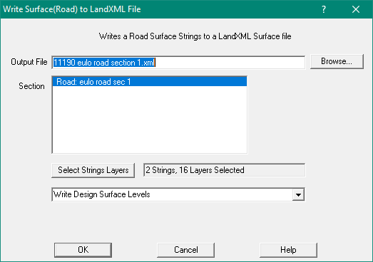
Section
Choose a longsection from the list presented, it will list all Road, Drain and Sewer Longsections in the job.
Select Strings by Layer
Select the layer(s) containing the required strings
Design or natural Surface Levels
If the road has a design surface you should write out the Design Surface levels.
Machine Guidance Files
Two files required for machine guidance.
1. The Alignment (longsection) file
2. The Surface File
You must prepare your job data carefully and then generate each of these files separately.
The Write Alignment to LandXML File option should be used to generate the Alignment file
This option (above) is used to generate the Surface file.
Preparing Job for Surface File
- Create an Alignment file following instructions in link above
- When defining Cross Section template, give each significant point a suitable code.
You may need separate CS templates for left and right sides so that the point codes are uniquely named
- Use the Strings/Form strings option (or do it manually) to create parallel Traverse strings joing points of the same code
- These strings will run along the road.
- These will form the Breaklines - see below
- These strings should be on the same layer as the road. Do not have any other strings on this layer
- Create a Boundary String around the design surface of the road. Use same layer as Road
This will form the Boundary - see below
- The boundary should encompass at least to the batter intersection point
Surface File Format
This is a standard XML file format, with data format defined by the LandXML standard.
This is a sample of some Surface file data
  <Surfaces>
    <Surface name="Webb RD MC01 (Finish)">
      <SourceData>
        <Breaklines>
          <Breakline brkType="standard">
            <PntList3D>7018997.96297 473207.95984 124.61100 7018997.13100 473209.58234 123.69931 ...</PntList3D>
          </Breakline>
          <Breakline brkType="standard" name="EB1">
            <PntList3D>7017351.07052 470000.82923 128.96881 7017350.70618 470001.12732 128.73344 ...</PntList3D>
          </Breakline>
			....
        </Breaklines>
        <Boundaries>
          <Boundary bndType="outer" edgeTrim="true" name="Outer edge">
            <PntList3D>7018997.96297 473207.95984 124.61100 7018997.39958 473206.86692 124.96540  ...</PntList3D>
          </Boundary>
        </Boundaries>
      </SourceData>
    </Surface>
  </Surfaces>
Explanation
- <Surfaces> - indicates the start of Surfaces section, we only have one surface in a file
- <Surface name="Road1"> - name is the name of the longsection string;
- <SourceData> - This is the start of the data
- <Breaklines> - Start of the breaklines/String data
- <Breakline brkType="standard" name="ED1"> - Defines a string/breakline
- <PntList3D>7018997.96297 473207.95984 124.61100 ....</PntList3D> - The co-ords for the points on the string (N,E,Z)
- </Breaklines> - End of the breakline/String
- ... multiple Breaklines/Strings appear here...
- </Breaklines> - End of the breaklines/String data
- <Boundaries> - Start of the boundaries data
- <Boundary bndType="outer" edgeTrim="true" name="BDY1"> - Defines a boundary String around the data
- <PntList3D>7018997.96297 473207.95984 124.61100 ....</PntList3D> - The co-ords for the points on the boundary string (N,E,Z)
- </Boundary> - End of the boundary
- </Boundaries> - End of the boundaries data
- </SourceData> - end of the data
- </Surface> - end of the surface data
- </Surfaces> - end of all the surface data